| |
| Home |
| Memorial Sites |
| Registration |
| Rider List |
| Riders Forum |
| FAQ |
| Links |
 |
 |
| Kingfisher County War Memorial |
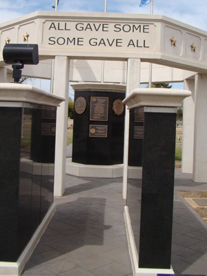 | Kingfisher, Oklahoma Kingfisher Cemetery's war memorial is a large monument located near the entrance to a cemetery. It consists of a white pavilion-type structure in the center, and includes numerous tall black columns of text. As you enter the monument from the south (cemetery entrance) the first thing you come upon is a pair of military boots with the rifle and helmet, on top of a pedestal with a plaque, "In Memory of Our Fallen Comrades Who Gave All." Also in the area: Runs of ’89 and ’92 markers, on OK-33, just west of the cemetery entrance. The Run of ’89 West Boundary The Run of ’92 East Boundary –––––––––––––––––––––––––––––––––––––––––––– |
|
||||||
| Ask about being a sponsor | ||||||

|